BEAT has been working to improve habitat connectivity in Western Massachusetts for several years now. Roads represent a significant barrier to wildlife movement, subdividing the landscape, fragmenting and degrading habitat, and contributing to wildlife mortality due to vehicle collisions. These issues don’t only apply to terrestrial wildlife, either; roads intersect with streams and rivers frequently, forcing undersized pipes and culverts to be installed underneath roads in order to funnel the water from one side to the other, often causing significant negative impacts on these ecosystems.
To address this issue, BEAT is collaborating with transportation planners, biologists, universities, and locals to identify, survey, and analyze road segments within linkage zones (also known as wildlife corridors) and road-stream crossings.
In short, BEAT’s Connecting for Wildlife program aspires to maximize motorist safety by reducing vehicle-wildlife collisions and minimize the ecological footprint of roadways by improving landscape connectivity, including waterways like rivers and streams.
Visit our Wildlife Connectivity Surveying page to learn more about the difference between terrestrial and aquatic connectivity and how the surveying techniques compare to each other. We’re also actively training/certifying people on these surveying protocols. If you’re interested in this volunteer fieldwork, please review the specifications and email [email protected] to let us know.
CHURCHILL BROOK: A VICTORY FOR TERRESTRIAL & AQUATIC WILDLIFE
In 2013, BEAT, the Housatonic Valley Association (HVA), and the City of Pittsfield undertook a long-term project to restore the natural aquatic connectivity of Churchill Brook.
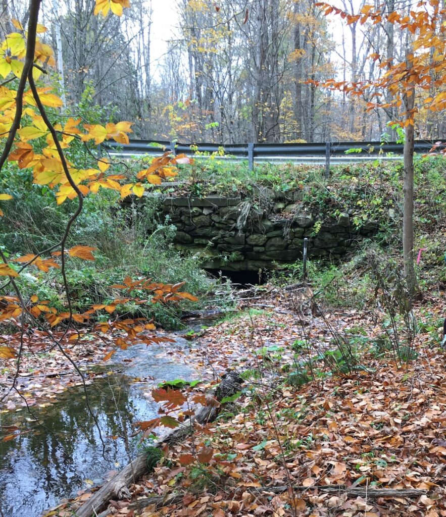
Churchill Brook has its headwaters in Pittsfield State Forest. The only human-made obstructions on this brook were two undersized culverts, one at Churchill Street and the other at Hancock Road — both in Pittsfield, MA.
The goals of this project were to:
- Restore aquatic connectivity in Churchill Brook
- Ensure the new stream crossings would last 100 years and could pass the new 100-year (1% chance) flood waters that climate disruption is bringing
- Restore the natural transport of nutrients and sediments downstream
- Allow for terrestrial wildlife passage under both roads most of the year (except during high water flow events)
- Reduce the maintenance burden of these crossings on the highway staff in Pittsfield
During the winter of 2020-2021, an undersized culvert (pipe under the road) was replaced with a bridge that spans 1.2 times the bankfull width on Churchill Brook. Previously, no wildlife could cross under Churchill Street, and BEAT had documented deer in the road and at least one that had likely been hit and killed at this location.
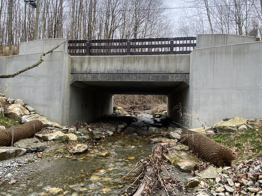
Using winter tracking, BEAT documented mink passing under the bridge during the winter of 2022-2023, and in the spring of 2023, we began to see other wildlife using this bridge to pass under Churchill Street. Wildlife using the crossing include raccoon, opossum, bobcat, deer, and a deer with her fawn. Click here to watch a video compilation of the wildlife caught on trailcam using the underpass.
You can also read our 2023 Report for this project here.
BERKSHIRE WILDLIFE TRACKERS
In addition to identifying potential crossings and surveying infrastructure, BEAT has been actively working to get more people trained in wildlife tracking — and not only because tracking is fun. Being able to identify wildlife track and sign is an invaluable tool in the connectivity surveying arsenal. Having skilled trackers as a resource in connectivity allows us to know exactly where wildlife are crossing and what species are doing so!
During the winter of 2007-2008, BEAT took on the task of getting our first group of Berkshire Wildlife Trackers trained. We hired Sue Morse, the founder of Keeping Track and one of North America’s top wildlife trackers, to join us in the Berkshires and train people. This eventually led to the creation of Mass Wildlife Trackers in 2008, which became the Northeast Wildlife Trackers.
In addition to creating this forum of wildlife-tracker enthusiasts throughout the region, we’ve been able to provide training in Keeping Track to over 70 people here in the Berkshires, in addition to offering CyberTracker trainings and workshops with other wildlife tracker professionals.
Each winter, we organize tracking hikes with skilled trackers throughout the county. If you’re interested in joining our email list for updates on these, email [email protected] and let us know. Click here to find a compilation of wildlife tracking resources.
INTERNATIONAL RECOGNITION
In June 2023, at the International Conference on Ecology and Transportation (ICOET), BEAT received a stewardship award for our work protecting and re-connecting wildlife habitat in the Berkshire Wildlife Linkage area. This effort is part of a larger Staying Connected Initiative: a partnership of many conservation organizations that work together to maintain landscape connectivity across the Northern Appalachians in the Acadian Region of the US and Canada.
PARTNERS


RESOURCES
We have several pages with compiled lists of wildlife-related resources here on our website. Visit the Resources page and scroll down to the Wildlife section to find them.
Report wildlife roadkill, amphibian crossings, and turtle deaths on Linking Landscapes for Massachusetts Wildlife
Berkshire Wildlife Linkage (part of the Staying Connected Initiative)
The Stream Continuity Portal (access to the NAACC database)
Road Ecology & Wildlife (BEAT resource page)