How Close is the Nearest House?
| Previous | 1 2 3 4 5 | Next |
According to Massachusetts Site Assignment Regulations for Solid Waste Facilities 310 CMR 16.40 (3) (d) Criteria for Solid Waste Handling Facilities:No site shall be determined to be suitalbe or to be assigned as a solid waste handling facility where [5.] the waste handling area of [b] any other transfer station or any handling facility is 500 feet from [i.] an occupied resedential dwelling. That is – no waste handling facility can be within 500 feet of a home.
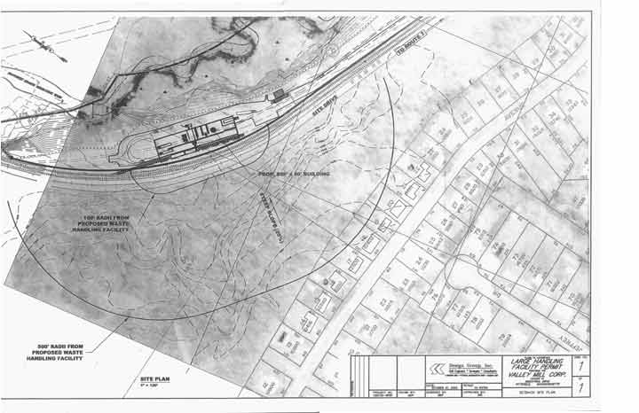
The above plan was submitted to the Massachusetts Executive Office of Environmental Affairs by SK Design Group on behalf of their client Valley Mill Corporation as part of their Environmental Impact Report. This plan is intended to show (in part) that the proposed building will be at least 500 feet from the nearest residence. SK Design Group has drawn a polygon indicating a radius of 100′ from the proposed building and another polygon indicating a radius of 500′ from the proposed building.
![]()
Above, BEAT has zoomed in on the plan and placed a grid of squares over it. The horizontal red lines line up with the side of the proposed building shown on the plan, but they do not line up with the sides of the two polygons. If these polygons really represented radii of 100′ and 500′ they would be parallel to the sides of the proposed building, and thus parallel to the horizontal red grid lines. The polygons appear to be rotated away from the houses.
![]()
This is part of the same plan rotated to overlay on a Massachusetts GIS aerial Photograph.
![]()
The above image is an overlay of the plan and a Massachusetts GIS aerial photograph. The two were registered by superimposing the railroad tracks of both images. The two sets of tracks registered perfectly along their entire length. But note that the buildings from the SK Design Group plan do not coincide with the buildings from the aerial photo.
![]()
This image shows the same overlay with the buildings from the SK Design Group plan outlined in red and the tracks highlighted in yellow. The nine houses closest to the polygon have also changed shape. Note that two of the houses (at the bottom of the image and indicated by BEAT’s green arrows) are L-shaped on the aerial photo and rectangular on the SK Design Group plan. The additions facing the polygon are missing, thereby increasing the apparent distance between the proposed building and the houses. Members of BEAT recently visited the houses to confirm that the houses are in fact L-shaped currently.
![]()
Interestingly, on another SK Design plan submitted at the same time as the above plan, but not intended primarily to show distance between houses and facility, the houses are again in the proper location and again have their L-shaped additions intact.
(SK Design Group’s Water Resource and Land Use Site Plan)